| Project: Norwegian Wind Atlas | Customer: NVE/ENOVA | Revision: 2.0.0 | ||||||
| Scenario: Troms 2 | User: VECTOR AS | Date : 30.04.01 11:01 | ||||||
| + | Wind Resources in Troms 2 |
| Average wind speed | ||||||||||
| The wind climate displays large seasonal variations. The average wind speed is presented for different averaging periods. | ||||||||||
|
Averaging period: Summer
|
||||||||||
| . | . | |||||||||
| . |  |
. | . |  |
. | |||||
| . |
|
. | . |
|
. | |||||
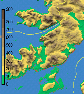
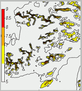
| Fig. 1 | Digital terrain model | Fig. 2 | Wind speed at 50 meters height | |||||||
 Measurement station
 |
Averaging period: Summer | |||||||||
 Interpolated or translated
 |
||||||||||
 Wind turbine(s)
 |
||||||||||
| Area classification | |||||||||||||||
| The total model area is: 678 km2 while the area above land is: 372 km2. The land area is classified in four groups according to the average wind speed at 50 meters height. The first and largest group cover the land area where the average wind speeds is above 6 m/s. The subsequent groups covers reduced areas as the average wind speed is increased to above 7 m/s, 8 m/s and 9 m/s. | |||||||||||||||
| The suitability of an area for wind energy purposes depends on the size of high wind speed areas. Further it will be an advantage if the high wind speed areas are grouped or connected. Table 1 classifies areas according to minimum wind speed and minimum size of connected sub-areas. | |||||||||||||||
| . | >6 m/s | . | >7 m/s | . | >8 m/s | . | >9 m/s | . | |||||||
| > 0.04 km2 | 52.5 | (14) | 14.1 | (3) | 3.3 | (0) | 0.4 | (0) | |||||||
| > 0.10 km2 | 51.5 | (13) | 12.4 | (3) | 2.1 | (0) | 0.1 | (0) | |||||||
| > 0.50 km2 | 44.9 | (12) | 7.1 | (1) | 0.0 | (0) | 0.0 | (0) | |||||||
| > 1.00 km2 | 38.5 | (10) | 1.4 | (0) | 0.0 | (0) | 0.0 | (0) | |||||||
| Table 1. | Areas in km2 classified in groups according to minimum average wind speed and minimum size of connected sub-areas, number in brackets is the area in the group as a percentage of the total land area | ||||||||||||||
| Energy production | |||||||||||||||
| The maximum theoretical energy production from the total land area with wind speed above 6 m/s is: 477 GWh /summer |
 |
||||||||||||||
|
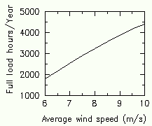
The energy production is based on an installed capacity of 15MW/km2.
The installed capacity will only be obtained when the wind speed typically exceeds 12-13 m/s.
For lower wind speeds a wind turbine produces its installed capacity only a fraction of the time, usually
expressed as full load hours. The right figure gives the relation between full load hours and average
wind speed used in the energy calculations in this study:
|
|||||||||||||||
| . | >6 m/s | . | >7 m/s | . | >8 m/s | . | >9 m/s | . | |||||||
| > 0.04 km2 | 477 | (100) | 162 | (33) | 45 | (9) | 6 | (1) | |||||||
| > 0.10 km2 | 461 | (96) | 140 | (29) | 28 | (5) | 1 | (0) | |||||||
| > 0.50 km2 | 387 | (81) | 77 | (16) | 0 | (0) | 0 | (0) | |||||||
| > 1.00 km2 | 318 | (66) | 14 | (2) | 0 | (0) | 0 | (0) | |||||||
| Table 2. | Energy production in GWh/summer for an installed capacity of 15MW/km2, the number in brackets gives the produced energy as a percentage of the total possible energy production for the land area. | ||||||||||||||
| Climatology | |||
| The wind resources in the model is based on the following wind climatology(s): | |||
|
|
|||
|
|
|||
|
|
|||
| Particular comments: The wind speed may be somewhat too high in the eastern part. Data from this model are especially uncertain. | |||
| General comments:
|
|||