Lidar and sodar flow curvature correction
How does it work?
You provide us the coordinates of your device and some additional information about its configuration in the form below. With this we can fetch terrain datasets of the surrounding areas which are used as an input in our CFD simulations.
The 3-D components of the simulated wind are extracted from the resulting wind flow model at the locations measured by the device. This information is aggregated in a similar manner as the device does (assuming homogeneous flow). By comparing this result with the actual simulated wind speed a correction factor is derived. This procedure is repeated for every directional sector, obtaining correction factors for each direction and height. Finally, the correction factors are applied to the original data depending on the measured wind direction.
Our procedure complies with IEC61400-12-1
You will receive a confirmation of your order. Within 72 hours after the confirmation, you will get a text file with the correction factor table. No NDAs or other type of contracts are required.
You can get a sample of the correction factor table files in this link.
LIDAR and SODAR flow curvature correction
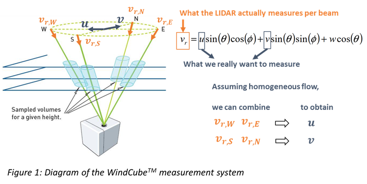
When a remote sensing device measures the wind in a point of interest, it actually doesn’t measure the point of interest, it measures several points surrounding the point of interest. To derive wind speed and direction in the point of interest, all sampled measurements are aggregated by assuming the wind conditions to be homogeneous. This basic assumption is not true in complex terrain—the wind field is not homogeneous in the surroundings of the point of interest—so systematic errors are introduced in the measurements.
To deal with these errors, WindSim offers a correction service based on our CFD technology. In a nutshell, we can simulate the heterogeneity of the wind flow at the device position and therefore adjust for the faulty homogeneity assumption.
Without correction, wind speed measurements could present deviations on the order of 3%, a profit difference of about 20 MEUR for a 120 MW wind farm.
WindSim can support multiple devices like WindCubeTM, ZX LIDAR, Triton and AQ System SODARs. For other devices please contact us.
Correction service tailored for WindCubeTM, Triton and AQ System SODARs
For WindCubeTM and SODAR devices we provide a specialized correction service. What makes it special is that our correction technique is based on the fact that these kinds of devices measure at few particular locations (Figure 1), in contrast to other technologies like continuous wave LIDARs. In addition, we consider the complete variability of the wind. Other techniques available in the market make use of “universal” corrections which are supposed to apply for any remote sensing device. These techniques only account for the wind aligned with the device and generally neglect the horizontal variability.
Our experience
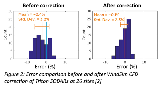
WindSim Service has been pioneering in Remote Sensing correction [1], with an extensive experience with more than 100 correction services provided globally. We also conducted one of the biggest validation campaigns for SODAR correction (Figure 2). WindSim software users have utilized our correction techniques for more than 10 years for all kind of remote sensing systems.
Contact: consulting@windsim.com
White papers & case studies
Correction of LIDAR remote sensing measurements by CFD simulations
Improving Remote Sensor Accuracy and Uncertainty in Complex Terrain
References
[1] Meissner C., Boquet M. “Correction of LIDAR remote sensing measurements by CFD simulations”, 2011, EWEA Brussels
[2] Stoelinga M., LaWhite N. “Validation of Triton Wind Profiler Measurements in Complex Terrain, Using WindSim CFD-Based Flow Curvature Correction”, 2018, whitepaper